


UCLG ASPAC IUC Asia Programme introduces Climate Risk and Vulnerability Assessment (CRVA) to its 13 pilot cities. Incorporating CRVA into development of Climate Action Plans (CAPs) will provide cities with evidence-based data to enable deep understanding of the current and future climate change risks, and how vulnerable a region is. Cities will also be able to ensure its climate actions address the specific situation and needs of people within the region; thus, effectively achieving the intended results. Recently, UCLG ASPAC IUC Asia Team has assisted Depok, one of pilot cities in Indonesia, in their CRVA step.
How CRVA Brings up Data on the Ground
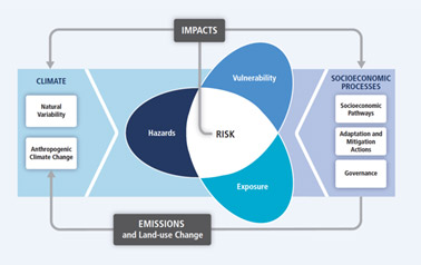
As reflected on its title, CRVA assesses city’s risks and vulnerability factors. To calculate the degree of city’s vulnerability, CRVA will firstly combine data representing city’s exposure level to climatic variations with data showing degree of city’s sensitivity to climatic influences. Both data are obtained from city’s statistics such as population density, residential area, clean water sources, slums, and so on. This calculation will incur quantitative data reflecting city’s potential impacts. CRVA will then combine it with city’s adaptive capacity (using data representing number of education and health facilities, open public spaces, finance centres, sources of livelihood, etc.) to get to know city’s vulnerability level. In the process, identifying these data will also help cities later on to see socio-economic elements/factors they need to focus on and improve in developing adaptation plan.
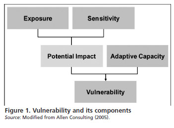
As for Risk, CRVA sees risk factor as potentials of consequences (e.g. loss, injury, adverse effects) given city’s vulnerability and climate change hazards.
Overall, CRVA looks at the concurrence of city’s vulnerability factor, exposure received, and hazards faced as well as other elements, such as socio-economic processes. Therefore, CRVA includes analysing past and current weather trends, projecting changes in climatic conditions, identifying exposure and sensitivity to those anticipated changes, as well as estimating adaptive capacity in terms of available financial recourses, human resources and adaptation options.
CRVA in Depok City
Introducing CRVA to the city of Depok (Indonesia), IUC Asia Programme incorporated the usage of SIDIK, an online platform introduced by the Ministry of Environment and Forestry of Indonesia, that calculates and maps out cities’ vulnerability level with data supplied by Village Potentials Statistics (PODES). SIDIK will incorporate data calculation on various variables such as availability of electricity, health facilities, education, road infrastructure, riverbank settlers, riverbank informal settlements, drinking water sources, the degree of poverty, and main source of income. From this calculation, city will know the degree of its vulnerability to climate change: be it very low, low, quite low, moderate, quite high, high, or very high.
Using the CRVA, Depok City found that Depok’s topographical conditions in the form of undulating lowlands with a gentle slope have caused serious problems with flooding and landslides in several areas. It was also found that climate risks often faced are floods and drought. CRVA also helped Depok to find its main capacity to deal with climate change including low number of slum and riverbank settlements, good educational facilities, adequate source of livelihood and environmental activities in almost all villages. CRVA also showed indicators that urgently need attention and improvement are population density, clean water sources, river normalisation and sources of livelihoods. The early assessment process shows that Depok City needs to put more attention on its ecosystem, poverty and local economy and livelihoods.
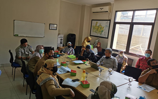
Moreover, from a CRVA workshop conducted on 28 July 2020, Depok City found gap between data and city’s recent condition. The outcome of the meeting suggested adding relevant indicators in order to enhance the result. The participants came to conclusion that the statistical data set would need to be readjusted with the historical data to reflect the actual condition. The changes would be reflected in the next CRVA meeting.
Moving to the next steps, Depok will ultimately be able to acquire climate risk priority maps on both extreme, for the current day and the future projection by combining SIDIK’s vulnerability maps and climate hazard projection maps, both on wet and dry extreme. Depok will have a location priority map that determines which area would require the most attention. This is one of the most vital guiding tools to design a well-targeted adaptation plan.